News + Trends
e/OS 3.0: Update for the Google-free Android version
by Jan Johannsen

In Google Earth, you can now follow the development of real places over the years: with Street View images from Google's archive, directly in the browser or the desktop app.
To mark the 20th anniversary of Google Earth, Google is introducing a new function that gives you a glimpse into the past: you can access historical Street View and satellite images in the desktop and web version of the virtual globe. Google Earth is thus expanding its perspectives and bringing a function that was previously reserved for Google Maps to the big globe for the first time.
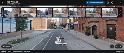
The new function allows you to select specific locations and track their development over the years. For example, you can see how neighbourhoods have changed, buildings have changed or landscapes have transformed. Street View Time Travel is integrated directly into the Google Earth user interface. As soon as you select a location with Street View data, a timeline appears that you can use to switch between different years.

This function is based on the extensive Google Street View archive, which has been continuously expanded since 2007. Millions of images from over 100 countries are available: many of them now also in Google Earth. The feature is to be rolled out further and further.
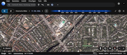
In addition to the new Street View timeline, you can also use satellite images to track changes on the Earth's surface. This is made possible by the function «Google Earth Timelapse».
Timelapse combines millions of satellite images from over 30 years: starting with the year 1984, sometimes even earlier. You can use it to see how:

Google is also working on additional analysis tools for Pro users that visualise tree canopy density and urban heat zones, for example. These will be available in the coming weeks
Google Earth was released on 28 June 2005 after Google acquired the company Keyhole. The software, originally known as «Earth Viewer», quickly became popular, with over 100 million downloads in the first week after its launch. Since then, Google Earth has evolved from a desktop application to a comprehensive web service that combines satellite images, 3D models, aerial photographs and now also historical street views.
Over the past two decades, Google Earth has not only been used for private exploration, but also for science, education and humanitarian aid. Researchers have used the platform to discover new reef systems, analyse environmental changes and locate fossil sites.
My interests are varied, I just like to enjoy life. Always on the lookout for news about darts, gaming, films and series.